Forest Ecosystems Daily: Classifying Communities

Image

E

At Ellicott Rock National Wilderness, we challenged students to assess the forest community, examining a small plot area in detail. Teams recorded species and percent cover in the canopy, mid-story, shrub, and herb layers, as well as measured the slope, aspect, plot profile and section, elevation, and soil depth and texture. Using a key, we then identified the community as an Appalachian Montane Oak-Hickory Forest (Typic Acidic Type). Knowing the community type can help protect rare species, for example, and are critical for conservation. [Plus, plants don’t run away.]

Running the Shut-In Ridge

10443079_10204609515860389_482215154559012344_o

Clouds and sunshine on the Blue Ridge Parkway. Photo by Andrew

Andrew, the boys and I camped in Pisgah National Forest for a rainy long weekend. I picked Flat Laurel Gap at Mt. Pisgah because of its elevation (5000 ft.) and proximity to some beautiful areas of western North Carolina. I’d never camped there before, though I’ve taken classes to the bog in the middle of the campground. We’ll definitely go back!

We lucked out on Saturday with the weather. I’d wanted to take the boys to the Shining Rock Wilderness, so we trekked the strenuous Art Loeb Trail above 6000 ft. to Ivestor Gap. After bushwacking (and feasting on wild blueberries) on Grassy Cove Top, we retraced our steps to find the trail, hiking to within sight of Shining Rock from Flower Gap, then turning back on the Ivestor Gap Trail for a challenging 8 mile loop. It was a glorious day, and they loved it as much as I hoped they would.

Family photo at the edge of the Shining Rock Wilderness.

My peeps at the edge of the Shining Rock Wilderness.

I’d had several recommendations for an out-and-back run on the wide and relatively easy Ivestor Gap Trail, but after trying to construct an elaborate route to meet Andrew and the boys at Graveyard Fields, I decided to simplify things and have Andrew drop me off at the NC Arboretum to run point-to-point on the Shut-In Trail. I’ve been intrigued by Shut-In for some time. It originated in the late 1800s as a path George Vanderbilt took from his Biltmore mansion up to his hunting lodge on Mt. Pisgah. In addition, there’s a wicked race there each November that I’d love to do sometime.

I knew it would be tough, even without running the full 16.3 miles. The trail gains a net 3200 ft. I figured 14.7 mi was as much as I could do—matching the distance I’d done in Charleston the weekend before but adding hills and terrain. My coach enabler best pal, Andrew, dropped me off at the Arboretum and we made plans to rendezvous at the 151 junction in three hours.

The run was as difficult as it was wonderful, and took me through some beautiful and varied stretches of forest. There were many not-runnable steep stretches, but also sections with a reasonable climb, including a few downhill breaks and flats that gave me the sinking feeling that I was going to pay for them later. [Which I did.]

I took my mind off the burning in my lungs during climbs by inventing a Tolkeinian forest classification. Either the oxygen was too limited or the connection was too tenuous, because I didn’t get very far.

Mirkwood.

Mirkwood.

???????????????????????????????

Lothlorien.

Maidenhair fern (and cove forests) must be Rivendell.

Maidenhair fern (and cove forests) must be Rivendell.

Shut-In has few views, though it does pop out on the Parkway now and then, usually at overlooks. Since it was either steady rain or mist, I didn’t miss much, though the elevation markers that I only glanced at from the car now took on new significance. However, fog makes the colors in the forest more vibrant anyway, and the wildflowers I saw were a good distraction.

Jewelweed, Impatiens pallida

Pale jewelweed, Impatiens pallida

???????????????????????????????

Starry campion, Silene stellata

???????????????????????????????

And a crazy fungus!

For some reason, I was reluctant to pull out my map, even as I ran by several Parkway checkpoints. I didn’t look because I was afraid of how far behind I’d be. Finally, at 2 hrs. 45 min., I looked to see where I was. Sure enough, I was even farther behind than I’d thought. I’d never make the 3 hour meeting point.

That’s when I realized that I should have had a back-up plan—at 3 hours, I should go to the closest Parkway overlook and wait for Andrew to find me if I wasn’t at the meeting point. As luck would have it, we were able to text, so after I emerged from the woods again, I asked Andrew to come south and pick me up at Big Ridge Overlook, at 12.3 mi. He and the boys showed up with a towel, Fritos, a sandwich and a chocolate bar. Best. Pit. Crew. Ever.

Lessons from Shut-In:

Gear: Water in my 70 oz. Nathan pack, 2 Justine’s nut butter packages (peanut butter/honey and maple/almond butter, delicious but sticky), a Luna bar, a Cliff bar that I didn’t eat, and a package of Fritos. Should have brought Nuun. I had a map (no compass—the trail follows the Parkway, so getting lost would be quite a feat), phone, small first aid kit, camera, and a page from my NC hiking guide with trail distances. I carried a long-sleeved shirt and a wool pullover in a plastic grocery bag, stuffed into the shock cords on the outside of my pack. I wore shorts, a t-shirt, a hat, and my Brooks Trail Adrenalines.

Train for distance, but account for time. When will I learn this? I can’t get my head around time-training for long runs, though I know many people like it. My mistake, though, is that I chose a distance but miscalculated my time. A 12 min. pace seemed generous, covering snack time, photos, and navigation. I might have been close had I not gained ~2000 ft. in elevation. Instead, I was closer to a 15 min. pace. Moreover, I knew I was behind and ran hard whenever I could. Fine for a race, dumb for a training run.

Plan smarter. I knew I couldn’t run the whole distance, so I should have had Andrew drop me off higher up, on the Parkway, so I could have run 14+ back to the campground. That way he and the boys would not have had to meet me, and I wouldn’t have worried that I was behind schedule.

Angles count. Shut-In was great training for my trail 50K, with long stretches of climbing. I can run, seemingly forever, on a gentle climb. But the tipping point comes eventually, where the steepness becomes not runnable, which turns suddenly into barely walkable without gasping for breath. I need to work on running steeper angles while breathing easy. Hill repeats!

Walk when you need to. Another great lesson to remember. Sometimes I pushed myself to run steep sections to the point of breathlessness. Then the trail would level out, but I was so out of breath by that point that I couldn’t run.

Mental focus matters. Shut-In was my second birthday trail run for Suzie (last year it was in Acadia). This year it was hard, and I felt it. Toward the end, I was so discouraged by the climbing that I had to stop, and I took a few pictures to re-group. I had a hard time pulling out of the downward spiral. Food did not seem to help. And then there were beautiful stretches where the running was easy and fast and I whooped aloud for the joy of flying, and of having known my amazing friend. Such is the strange nature of grief. 

Joy outweighs sorrow.

She would have loved this. RIP.

[“Bedshaped,” by Keane, has been playing in my head]

Not-quite-a-stage-run on the Bartram Trail

Finding a trail on a map doesn’t make it runnable. So I discovered a few weekends ago when I was exploring the Bartram Trail.

Haven’t heard of the Bartram Trail? It winds 100 miles through North Carolina and Georgia, approximately tracing the route of explorer-naturalist William Bartram.

I was out in the NC mountains teaching a 2 week summer field course (Forest Ecosystems of the Southern Appalachians) through the Highlands Biological Station. We had a day and a half off mid-course. What does a forest ecologist do on her day off, when she’s taught and hiked 20 miles the first week? A. Laundry. B. Sleep. C. Run trails through forests. Never one to miss out, I did them all.

Initially, I wanted to do these as a stage run, connecting two sections. My friend Joanna and I are plotting a local ultra-distance stage run this winter, and I wanted to think about how it might work. But I didn’t want to ask anyone to run shuttle for me, and I needed to see one section again for a book I’m working on. So I ran two sections that didn’t quite connect.

Section One: Warwoman Dell to past Martin Creek Falls (and back – 6 miles or so)

This section of trail is in Georgia, and I needed to see it again because I hiked it (twice) and then realized that I had never quite made it to Martin Creek Falls. How is that possible, you ask (implied: you doofus)? Well, Bartram called the falls Falling Creek, and so I thought the creek with some small drops on it was probably the falls. Then I saw another hiker’s photo of the falls. Apparently I hadn’t gone far enough, because I had not seen these falls. I had to go back.

Image

Bartram Trail sign at Warwoman Dell, outside Clayton GA.

I didn’t take many photos during the run, because I was too busy trying not to bust my butt on slippery bridges and roots. Funny, I was testing some Brooks Adrenaline ASRs and they had a great grip on everything except wooden bridges, where they were completely non-functional.

I ran past 2 sweet backcountry campsites before making it to the falls.

Image

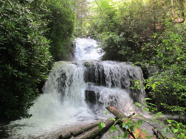
And now I can say I have seen Martin Creek Falls! Bartram wrote about the area while sitting at the base of this same waterfall in 1775.

With all the rain and storms this summer, there were obstacles.

Image

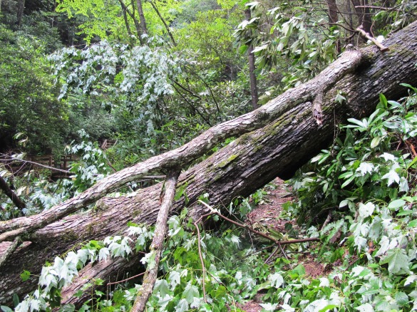
Lots of trail work ahead this fall.

Image

Made for some interesting bushwacking, though.

I wanted to see where the trail continued, because it seemed to end at the falls and I thought someday I’d like to continue a longer run or hike past this section. I bushwacked around for awhile but found nothing. Then I re-traced my steps to the campground and found another spur trail up to the falls (marked with the same blaze, yellow diamonds). No continuation. Finally, I found that there was another trail (again, marked with the same Bartram Trail blaze) that was the actual continuation of the trail. I ran along this for awhile (when the inclines allowed oxygen intake) before deciding I needed to turn around, having given an ETA to my friends and not wanting to be late. [Of course I had my phone! But I didn’t have any service.]

Image

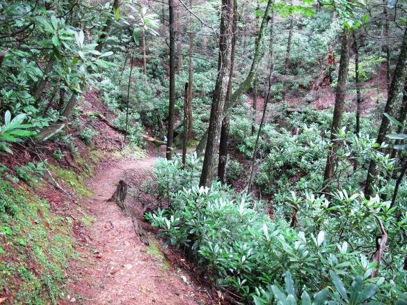
Yahooo! There were some fun descents along the way. This section was mostly runnable.

Section 2: Hale Ridge Road to Scaly Mountain (and back, about 11 mi RT that was actually 12+ with some additional route-finding)

Early on Sunday afternoon, I pulled myself away from the scourge of email and decided it was time to get out. A few bumpy miles down the dirt and gravel Hale Ridge Rd. and I was at the trailhead, the southernmost point of the NC Bartram Trail (in NC, the blaze is yellow rectangles). This point was about 17.7 miles from Warwoman Dell, so I skipped a 15 mile section in north GA that included Rabun Bald.

The first section, up to Highway 106, was fairly runnable. I had been wanting to do this section and see Hurrah Ridge. Who doesn’t want to explore side trails with names like Hurrah Ridge and Puc Puggy Trail? In the end, though, I had chosen Scaly Mountain as a destination, so I reluctantly left these intriguing trails for another day.

Image

I ran through pine-oak-heath forest, with numerous ravines and mini waterfalls–awesomely scenic, when I took my eyes off the ground.

???????????????????????????????

Fly poison, Amiathemum muscotoxicum. I didn’t say the name was beautiful.

I should have realized from the elevation profile that the 2 miles from NC 106 to the summit of Scaly Mountain would be tough, with a thousand feet of elevation gain. But I was looking for adventure, not speed, so I alternated climbing and hiking. This was a beautiful section of trail, through a gorgeous open montane oak forest with beautiful wildflowers, so I didn’t really mind taking it slow.

I also hiked for a bit with my two co-instructors, Julie and Alan, who were taking a more leisurely hike and photographs.

The next section was interesting. I’d describe it as Class 2 whitewater.

Image

This is not a view of a creek off to the side of the trail. This *is* the trail.

We’d had 14 inches of rain in the area in the first six days of class, and as I neared the summit of Scaly Mountain, the water poured off the trail, well over ankle deep in many places. It was amazing. I passed a garter snake near the summit, then reached the summit of Scaly Mountain and paused to rest and enjoy the views.

Image

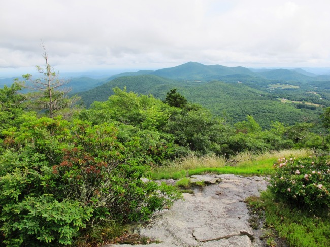
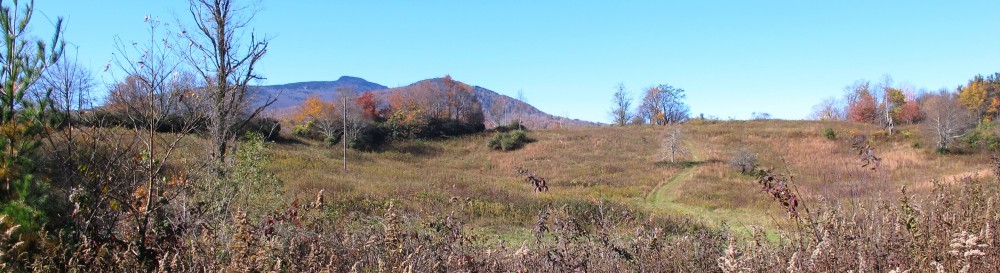
The reward of a steep climb. The peak in the distance is Rabun Bald, Georgia’s second-highest peak. Scaly Mountain, my vantage point, tops out just above 4500 feet. I started my run on the other side of the nearer peak. There is something satisfying about looking back where you came.

I scampered back down the trail, missing a switchback and ending up in somebody’s yard. Then I turned the wrong way when I got back on the trail, and was experiencing some serious doubt and déjà vu when I ran into a group of hikers coming toward me. A little sheepishly, I asked them if they were heading to the summit, or if they were heading down from the summit. They were heading down, the direction I *should* have been going. Drat. I turned around and made the switchback this time.

The rest of the run was pretty uneventful, but the extra mile or two of back-tracking made me glad to reach the car.

???????????????????????????????

Extreme speed botany. I brought back a few branches for my friends and co-instructors. FYI, there’s no such thing as a gift of flowers or leaves to fellow botanists–it’s either a prank, a question, or an ID challenge.

I returned to the Highlands Biological Station and started cooking dinner with Julie and Alan. “How was your hike? Did you make it through the whitewater trail up to the Scaly summit?” “We went through the flooded section, but we were turned around before the summit by some fauna.” “A bear?” “Nope. Did you miss the timber rattler?”   -PAUSE-   “I didn’t see a timber rattler. I saw a garter snake. I mean, I’m certain it was a garter snake. Geez, I hope it was a garter snake!” We compared photos.

???????????????????????????????

This is a garter snake. See his not-triangular head, cute stripes, and lack of rattles?

timber rattler on Scaly

And *this* is a timber rattlesnake. Have to admit, he’s beautiful! But I didn’t see him. (Photo by Julie Tuttle)

Whew!

It was a great way to spend a day off in the mountains, and I hope to run more of the Bartram Trail on my next visit. These kinds of solo adventures fill my introvert’s need for a re-charge when life gets crazy.

Eastern cougar

Image[I wrote the first draft of this poem on March 7, 2011, upon reading the news from the US Fish and Wildlife Service that the eastern cougar had been declared extinct. I’ve revised it off and on since then. This isn’t the final word–genetic evidence suggests that the Eastern cougar (Puma concolor couguar) was one variety of the North American cougar species. Yet, I felt a sense of personal loss–not as an ecologist, but as an ordinary citizen of my planet.]

Fearsome catamount of legend–
I heard today that you are gone.
Not the resounding blow of natural selection,
Nor a clash with a more worthy competitor–
An ending more befitting of a graceful and deadly beast.

Your predator’s skill made you vulnerable to human fears.
Hunted, then starved–your fortunes tied to white-tailed deer
Now overrun in the East without you there.
Habitat loss sealed your fate.
Not with finality, but with lingering doubts of your survival.

Murmurings grown louder over time
Fruitless surveys building the evidence of doubt
Outweighing finally the chance sightings, ever fewer,
Which sounded more and more
Like the stuff of myths and wishful thinking.

Some will say that your role as an apex predator
Negates your loss. Others will scorn the dollars poured into your recovery,
Citing legions of unloved species who have neither your charm nor your fury.
And yet, how can we be numb to the loss of the mighty ghost cat,
Known for its elusive beauty?

How many of us will feel the pang of a species lost?
And how many more must we yet lose
For us to feel the chill of our own fragility
Through the threadbare places
In the fabric of our humanity?

The green fire that Leopold saw in the eyes of a dying wolf
Has faded for the eastern cougar.
Another piece of wilderness extinguished
In the banality of pen on paper,
The final echo of a species lost.